Set amongst spectacular scenery, with magnificent wildlife on your doorstep, our pods are the perfect base for couples looking for the ultimate Island retreat. The pods are the perfect place to set off on a hike. We’ve selected just a handful of walks, easily accessible from the Island Pods site for all ages and abilities to enjoy.

Summit Ben More
One for all the Munro baggers out there – Ben More is the island’s only Munro. Standing at 966m elevation, Ben More is the highest peak on the Scottish Isles and makes for a spectacular hike.
Ben More means ‘big hill’ in Gaelic and it certainly lives up to it’s name. From the summit (on a clear day) you can discover 360 views across Mull and far beyond.
Total time – 5-7 Hours
Total distance – 9.5km
Start point – Dhiseig car park (6km from Island Pods – add an extra hour if walking)
Difficulty – Moderate
Forecast – Ben More weather report
OS Map – 375 Mull East
The path to Ben More is a well trodden, safe route accessible to all hiking abilities (assuming enough snacks are provided). Keep a close eye on the forecast and try to pick the best day for visibility – we promise you wont be disappointed!
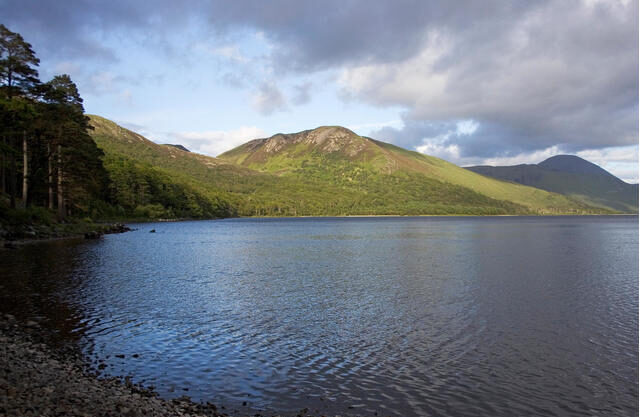
Explore the shores of Loch Ba
Nestled in the hills above the Benmore Estate lies Loch Ba. Providing perfect tranquillity for fishermen and hikers alike – stroll along the shore to enjoy the mountainous views (without the demanding climb!).
Total time – 2 Hours
Total distance – 8km
Start point – Your doorstep/Knock – Isle of Mull
Difficulty – Easy
Forecast – Knock weather report
OS Map – 375 Mull East
Starting at Gruline follow the signposted track to Macquarie Mausoleum before continuing past the buildings at Gruline and following the path along the north east shore of Loch Ba. This is a beautiful part of the loch, with mature woodlands and pebble beaches.
Not into hiking? Try fishing on Loch Ba with our sister site. Hooked on Mull.

Galivant through Glen Forsa
Glen Forsa is a largely open glen in the very heart of Mull, dominated by the peak of Beinn Talaidh at its head.
As part of our sustainability strategy we have commenced plans for a large scale native broadleaf woodland creation scheme to compliment the existing forestry and enhance the amenity value, biodiversity and natural capital of the estate.
Total time – 2-3 Hours
Total distance – 10km
Start point – Glen Forsa
Difficulty – Easy
Forecast – Glen Forsa weather report
OS Map – 375 Mull East
There is a gravel vehicle track which gives easy access to the start of the hike. Highland cattle and sheep are farmed here and there is much wildlife, with red deer and eagles being a common sight. The track continues to follow the course of the river until you reach the MBA run bothy Tomsleibhe.

Loch Na Keal
Stroll along the shores of Loch Na Keal – the prominent sea loch on the Atlantic coast. The perfect place to spot Mull’s resident otters or the majestic sea eagle.
Total time – As long or as short as you like
Total distance – 1-12km
Start point – Your doorstep/Knock – Isle of Mull
Difficulty – Easy -Moderate
Forecast – Knock weather report
OS Map – 375 Mull East
A gentle stroll or a longer day hike – Loch Na Keal stretches for almost 14 miles and can be as calm as a mirror (or as rough as the North Atlantic). A short stroll along the Northern edge to Killiecronan and back will take you just one hour – the perfect dog walk!

Climb a Corbett
Dùn da Ghaoithe (Scots Gaelic for ‘Forth of the Two Winds’) is Mull’s second highest mountain. At 2,513 feet (765.9 metres) high, this gem stands out as the island’s only Corbett. Although 201 metres below the summit of Ben More, don’t be fooled into thinking this is a gentle climb. This Corbett has a kick in her step that comes in the form of a thrill-inducing ridge and deep brooding quarries. The summit offers some of the best views of the Island, stretching across the hills of Mull all the way to the emerald sea.
Total time – 4-5 hours
Total distance – 15km
Start point – Craignure
Difficulty – Moderate
Forecast – Craignure weather report
OS Map – 375 Mull East

Ardalanish Bay
Ardalanish Beach is a long stretch of silver sand, fringed with machair, wild flowers (June to September) and sand dunes – famed for its geology and views to Jura. A reasonably easy walk in general, however there is an optional steep scramble to the top of the fort with sheer cliffs on the north, south and east sides.
Total time – 1.5 hours
Total distance – 6.5km
Start point – Unsurfaced car park between Ardachy Hotel and Ardalanish Farm
Difficulty – Easy
Forecast – Ardalanish Bay weather report
OS Map – 373 Iona, Staffa and Ross of Mull
Be sure to visit Ardalanish Weavers at the farm to see the looms in action, with wonderful textiles and craft products and food products from the farm on sale.


Newsletter signup
To receive all of our latest news, updates and offers straight to your inbox, please enter your email address below.
Follow us
We share a lot of different types of news, events, videos and photo on our other channels too. Why not follow us?